Autodesk has given us a new tool to play with... a new extension to publish Civil 3D to Google Earth. Now this is a different program than the one that was shown to us a couple of weeks ago, which was EXPORTGOOGLEEARTH.
Here is a list of some key features.
- Take complete control over the data you want to publish and how you want it to display including symbology and elevation
- Add layers of available Google Earth data including buildings, transportation systems, roads, etc to view your project within the context of the surrounding area
- Publish Civil 3D objects as Google Earth placemarks allowing you to quickly locate and navigate to a specific place on your project site
-Create drive-throughs along road centerlines and save snapshot views of your project site from different vantage points
- Associate points in your Civil 3D model with realistic 3D content (in KML format) such as light poles along a street, houses, or cars
- Publish your data using the coordinate system already specified in your drawing, pick from over 100 coordinate systems at publishing time, or apply a user-defined coordinate system.
Publish to Google Earth. The Autodesk® Civil 3D® 2007 Extension for Google Earth™ allows you to publish intelligent Civil 3D objects (geometry and metadata) including points, parcels, alignments, corridor models, surfaces, and hydraulic networks directly from Civil 3D to Google Earth. Through the wizard-driven interface, you have complete control over what data you want to publish and how you want it to display including symbology and elevation.
Download the Autodesk Civil 3D 2007 Extension for Google Earth:
http://usa.autodesk.com/adsk/servlet/index?siteID=123112&id=7294687&linkID=3549304
Download Google Earth:
http://earth.google.com/
Important: To install the Autodesk Civil 3D 2007 Extension for Google Earth, you must have Autodesk Civil 3D 2007 already installed. To run the Autodesk Civil 3D 2007 Extension for Google Earth, you must also have Google Earth installed. The Autodesk Civil 3D 2007 Extension for Google Earth works with the free version of Google Earth, Google Earth Plus and Google Earth Pro.
May 26, 2006
May 5, 2006
Trimble Link Now Available
The Trimble Link software is now abailable for the LDT and Civil 3D 2007.
Follow the Link: http://www.trimble.com/link_ts.asp?Nav=Collection-27103
Follow the Link: http://www.trimble.com/link_ts.asp?Nav=Collection-27103


May 2, 2006
Getting Back Into the Groove
Sorry I haven't posted in a while. I had a new addittion to the family, a baby girl. So things are starting to get back to normal, if that is possible. I will be posting shortly on some of the new features along with some tricks for the new products.
A question for you... What is it that you want to know more about?
I also got some comments that this info is great but most users were not able to go in and see for themselves the functionality. It seems like everyone is still waiting to recieve their software.
A question for you... What is it that you want to know more about?
I also got some comments that this info is great but most users were not able to go in and see for themselves the functionality. It seems like everyone is still waiting to recieve their software.
March 31, 2006
Civil 3D 2007 Activation Update
It's Back. We have a Hotfix available for 2007 to address an activation problem with anyone using SATA RAID controllers. There are 2 fixes, one for 2006 and one for 2007. This was a known issue in 2006, why on earth is this back?
DO NOT INSTALL THIS UPDATE ON A COMPUTER THAT DOES NOT HAVE A SATA RAID CONTROLLER. (read the fine print)
DO NOT INSTALL THIS UPDATE ON A COMPUTER THAT DOES NOT HAVE A SATA RAID CONTROLLER. (read the fine print)
This update corrects a problem that requires you to reactivate your Autodesk® product whenever you restart it.
Error Message:
After you activate and then restart your product, you receive error 0.1.0011 or 11.1.6011 and are required to reactivate. This problem can occur for Autodesk's 2007-based products on computers with SATA Raid controllers.
Note: This update must be applied to all computers that share a license. Therefore, if you apply this update to one computer and then want to use the Portable License Utility to transfer the license to another computer, be sure to install the update on that computer, too.
If this update is applied to a computer that does not have a SATA Raid controller, the license on that computer will be broken. You will need to reactivate the product to repair the license.
March 24, 2006
Civil 3D 2007 Preview Webcast & Future Webcasts
Great job today, Autodesk. After that awesome teaser we had today by the Autodesk, I am really excited to see my users get into this software and have some fun. This release is a true “production” tool. This will be the year that most users will start moving to the new technology and maybe even enjoy the change. Yes, change is good.
Follow this link to access the Autodesk Civil 3D Webcasts
http://usa.autodesk.com/adsk/servlet/item?siteID=123112&id=3856538
Here is a brief overview of what is to come.
March Webcasts
3/31/06 - Civil 3D 2007 Project Capabilities
Presenter: Dan Philbrick, Civil 3D Development Manager
April Webcasts
4/07/06 - Digging in to Civil 3D 2007 Survey Capabilities
Presenter: Rob Todd, Civil 3D Product Designer and Licensed Professional Surveyor
4/14/06 – New Grading Capabilities in Civil 3D 2007
Presenter: Dave Simeone, Civil 3D Product Manager
4/21/06 – New Production Drafting Capabilities in Civil 3D 2007
Presenter: Dave Simeone, Civil 3D Product Manager
4/28/06 – Use Digital Elevation Models (DEMs) and Satellite Imagery with Autodesk Civil 3D and Autodesk Raster Design
Presenter: Matthews Mathai, Autodesk Raster Design Product Manager
Follow this link to access the Autodesk Civil 3D Webcasts
http://usa.autodesk.com/adsk/servlet/item?siteID=123112&id=3856538
Here is a brief overview of what is to come.
March Webcasts
3/31/06 - Civil 3D 2007 Project Capabilities
Presenter: Dan Philbrick, Civil 3D Development Manager
April Webcasts
4/07/06 - Digging in to Civil 3D 2007 Survey Capabilities
Presenter: Rob Todd, Civil 3D Product Designer and Licensed Professional Surveyor
4/14/06 – New Grading Capabilities in Civil 3D 2007
Presenter: Dave Simeone, Civil 3D Product Manager
4/21/06 – New Production Drafting Capabilities in Civil 3D 2007
Presenter: Dave Simeone, Civil 3D Product Manager
4/28/06 – Use Digital Elevation Models (DEMs) and Satellite Imagery with Autodesk Civil 3D and Autodesk Raster Design
Presenter: Matthews Mathai, Autodesk Raster Design Product Manager
C3D 07 - System & Server Requirements
Direct From Autodesk -
Recommended System Requirements
The following system requirements are recommended for effective use of Autodesk Civil 3D 2007 software.
Autodesk Civil 3D 2007 recommended configuration (excluding server components that are used with project management capabilities):
Recommended Server Components
Server components (required for the project management feature) can be installed on the same computer as Autodesk Civil 3D 2007 if the computer is compliant with these recommended server requirements:
For once it looks like Autodesk actually gave us feasible system requirements.
Bump up the RAM... Get a new ATI 1GB Video Card... Dual Monitors... (oh sorry back to reality)
Recommended System Requirements
The following system requirements are recommended for effective use of Autodesk Civil 3D 2007 software.
Autodesk Civil 3D 2007 recommended configuration (excluding server components that are used with project management capabilities):
Intel® Pentium® IV processor, 3 GHz or higher
Microsoft® Windows® XP Professional or Home Edition (SP2), Windows XP Tablet PC Edition (SP2), or Windows 2000 (SP4)
2 GB RAM
5 GB free disk space for installation
1280x1024 with true color, OpenGL®-capable workstation class graphics card or DirectX® 9 support
Mouse, trackball, or compatible pointing device
Microsoft Internet Explorer 6.0 (SP1 or later)
DVD drive
Recommended Server Components
Server components (required for the project management feature) can be installed on the same computer as Autodesk Civil 3D 2007 if the computer is compliant with these recommended server requirements:
Intel® Pentium® IV processor, 3 GHz or higher
Windows XP Professional or Home Edition (SP1, SP2), Windows 2000 (SP4), Windows 2000 Server (SP4), Microsoft Server 2003 (SP1, SP2), Microsoft Server 2003 Enterprise (SP1, SP2), Windows XP Professional x64 Edition, Windows Server 2003 x64 Edition, Microsoft IIS
1 GB RAM
60 GB free disk space for installation
Mouse, trackball, or compatible pointing device
Microsoft Internet Explorer 6.0 (SP1 or later)
DVD drive
For once it looks like Autodesk actually gave us feasible system requirements.
Bump up the RAM... Get a new ATI 1GB Video Card... Dual Monitors... (oh sorry back to reality)
Have Your Voice Be Heard
Calling all complainers (or maybe just some constructive criticism). There is a new discussion group that lets your voice be heard.
Civil 3D Wishes. Follow these links
autodesk.civil3d.wishes ... for news readers
http://discussion.autodesk.com/forum.jspa?forumID=185 ... for web browsers
Civil 3D Wishes. Follow these links
autodesk.civil3d.wishes ... for news readers
http://discussion.autodesk.com/forum.jspa?forumID=185 ... for web browsers
March 14, 2006
Convert Land Desktop Points
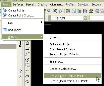
The convert Land Desktop points feature is not really new to Civil 3D. This utility could be downloaded from the Autodesk Support website under the Utilities & Driver section.
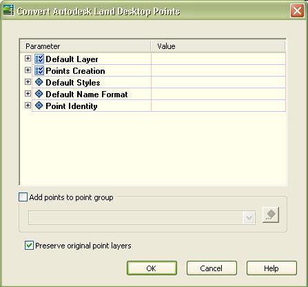
In the 2007 release this conversion utility was added to the Points menu, located under Utilities. After selecting the "Convert Land Desktop Points" option, a dialog box will appear prompting you to select parameters to apply to the new Civil 3D Point objects. You can set a variety of point settings such as, default layers, point creation settings, default styles, default name format, and point identity. Users can also select a default point group to which these points will be applied. There is also a check box to indicate if the original point layers are to be preserved enabling us to transfer directly from LDT to Civil 3D.
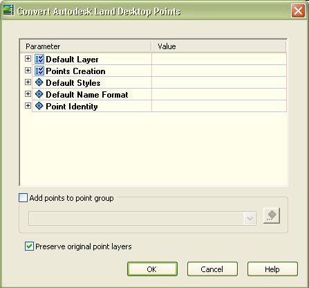
This command provides another layer of functionality for getting point data into Civil 3D from Land Desktop. Some other transfer methods would include XML import/export, importing Land Desktop Data, and exporting/importing of points. Some care should be taken to preserve data integrity. If you are planning on using your file in Land Desktop, there is no utility to convert back to Land Desktop Points.
March 6, 2006
Thanks
Thank You,
Thanks to Angel and Jason for their support of my new blog.
With all the new features included in the 2007 product, it's gonna take a small army to cover them all.
C-ya at Boot Camp.
Thanks to Angel and Jason for their support of my new blog.
With all the new features included in the 2007 product, it's gonna take a small army to cover them all.
C-ya at Boot Camp.
C3D 07 - New Labeling Feature
Alas, we may be able to put the debate on whether to label in layout (paper) or model space. This is one of those topics that we could argue til the cows come home. But I think with the new label feature, within Civil 3D 2007, we could have the answer. This new feature allows a user to create their own notes or labels that contain any type of text. You can edit the text similar to the way you edit Mtext or Dtext. Just type it in. As with other labels is Civil 3D, we can have the text plan readable and size according to our viewports. Another great feature is the ability to mask labels in 2007. No more having to position text so that it is not obscured by any other feature on your plans. This is one of those options that Autodesk should add to "vanilla" AutoCAD.
March 2, 2006
Autodesk Civil 3D 2007
Some Awesome New Features
Survey Functionality
Cleanly integrated into the Civil 3D toolset and user interface, providing a consistent environment for all tasks, such as fieldbook import, least squares adjustment, editing of survey observations, management of point groups, creation of surfaces, layout of parcels and alignments.
Grading Improvements
New collection of powerful day-lighting and grade projection tools can be used to generate surface models for any type of grading project, enabling you to modify groups of grading projections to quickly solve complex design problems.
Labels
Create and edit a single label that contains data from various objects or types of objects in your model.
Vault Explorer
Track work in progress, maintain version control in a multiuser environment and improve design reuse by consolidating product information in one place.
Pipe Layout/Design and Interference Detection
Expanded ability to set and customize Pipe Rules to account for regional, company and client standards for pipe design and layout, and an added system for interference detection between pipes helps to reduce errors, save time and increase productivity.
Survey Functionality
Cleanly integrated into the Civil 3D toolset and user interface, providing a consistent environment for all tasks, such as fieldbook import, least squares adjustment, editing of survey observations, management of point groups, creation of surfaces, layout of parcels and alignments.
Grading Improvements
New collection of powerful day-lighting and grade projection tools can be used to generate surface models for any type of grading project, enabling you to modify groups of grading projections to quickly solve complex design problems.
Labels
Create and edit a single label that contains data from various objects or types of objects in your model.
Vault Explorer
Track work in progress, maintain version control in a multiuser environment and improve design reuse by consolidating product information in one place.
Pipe Layout/Design and Interference Detection
Expanded ability to set and customize Pipe Rules to account for regional, company and client standards for pipe design and layout, and an added system for interference detection between pipes helps to reduce errors, save time and increase productivity.
Subscribe to:
Posts (Atom)