September 11, 2006

Civil 3D Webcasts - Get Signed up!

Last week we were introduced to the new Civil Engineering Community. I have noticed that there are quite few users that have actually signed up and are using the site. One area that I would like to point your attention to is the webcasts.

After setting up your login and profile, you can select on Events and then select Webcasts. After selecting Webcasts, you will then see the available webcast schedule. Be sure to click on a the title of a webcast. You will be ported to a registration web page where you can select which webcast you would like sign up for. Using this function, you will receive notifications for the webcast you registered.
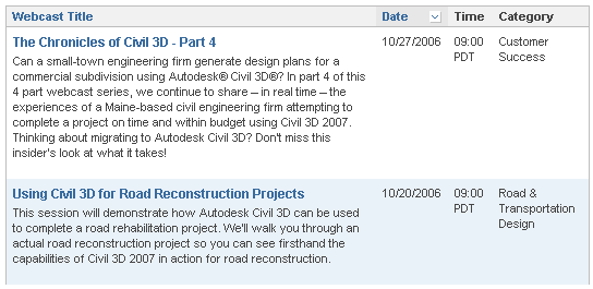

You now are required to register for the webcasts. So get signed up.

Be sure to click on webcasts located below the "featured webcast". If you select on a featured webcast, you will be taken to the Live Meeting website.



September 5, 2006

New Civil Community Web Site

As promised the new Civil 3D Community Website is up and running.

Follow the link and setup a profile and you will be on your way to an abundance of information.

http://civilcommunity.autodesk.com/

Key benefits of the community:

Peer network – Build member profiles, find and communicate with others who have similar interests, and start special-interest discussion groups.

Tips and training – Browse member-submitted productivity tips, detailed tutorials, training resources, and industry-related articles.

Content sharing – Upload/download templates, styles, design standards, reports, and custom utilities.

Blogs – Read blogs from Autodesk Civil 3D product management and marketing as well as members of the community.

Discussion groups – Participate in the Autodesk Civil Engineering Discussion groups, which are now integrated into the community experience.

Events – Search for partner events, user groups, and Autodesk webcasts from a central location

Service Pack 2 Now available

Follow the link:

http://usa.autodesk.com/adsk/servlet/ps/dl/item?siteID=123112&id=8021641&linkID=3549304

Service Pack 2 also contains all the fixes included in the Autodesk Map 2007 Service Packs 1 and 2.

Important:

The following standard template files (*.dwt) have been recreated due to issues found with Pipe Network Parts Lists. Some Network parts lists may be corrupt if you use .dwt files from the Autodesk Civil 3D 2007 release. The new template files will be posted at
http://civilcommunity.autodesk.com/._Autodesk Civil 3D (Imperial) NCS Base.dwt_Autodesk Civil 3D (Imperial) NCS Classic.dwt_Autodesk Civil 3D (Imperial) NCS Extended.dwt_Autodesk Civil 3D (Metric) NCS Base.dwt_Autodesk Civil 3D (Metric) NCS Classic.dwt_Autodesk Civil 3D (Metric) NCS Extended.dwt

Important:

Version 1 of the Google Earth Extension is only compatible with Autodesk Civil 3D 2007 and Service Pack 1 or 1A and will be disabled after you install Autodesk Civil 3D 2007 Service Pack 2. In order to use the Google Earth Extension, after installing Autodesk Civil 3D 2007 Service Pack 2, you must download and install Release 2 of
Google Earth Extension.

August 29, 2006

Civil 3D Community

Autodesk has just revealed that a new website featuring Civil 3D and it's users will becoming live in the not so distant future. I would expect to see it after the holiday (wink).

The new website will be a Civil 3D Community. This site will feature all the resources that most of you frequent in a normal day. The nice thing is that you can now go to one location and get all the info you need. It will feature a login and password and allow for customization of the content you will see based on your profile.

Some of the content will feature Tips and Training, Content Sharing, links to blogs, discussion groups, and online resources. It will also feature a My Network section that will profile users. There will also be a section listing events coming to your area.

Have you ever tried to find that link to the webcast so you could see what was up and coming. Look no further there is a complete list of all webcasts and events right on your home page.

From the sounds of it, this site is basically ours to do with what we want.

I do believe this is going to be a great resource for all of us. There has been a site like this in the Manufacturing sector for a while now. My "nuts and bolts" guys tell me it was awesome to have a site where you could find whatever it was you were looking for.

I will posting a link when the site becomes live (tweet... tweet... next week).

July 28, 2006

Chronicles of Civil 3D

Date: Friday, July 28, 2006
Time: 9:00 a.m. - 10:00am (PDT)... That's the lunch hour for us "east coasters"

Simply register for the "Chronicles of Civil 3D" webcast.
(You must register for this webcast)

http://hub.autodesk.com/index.php/view/p/1481.html?ch=US_dotcom

Over the next few weeks, we will be able to see some of the "pain points" and satisfaction associated with Civil 3D and its implementation. I believe these webcasts are going to help a lot of the companies sitting on the fence trying to make that decision... Should we or Shouldn't we? I also believe that these webcasts may help some of those companies say: Hey! This is the future and what do we need to get there? How do we get up and running with little or no downtime? This stuff is new and different than the way we have always done it in the past with Land Desktop.

So, I invite you to drink the Kool-Aid and experience the refreshing new way to do things. Yes, it will be difficult and sometimes frustrating (speaking from experience), but the rewards can be endless.

July 25, 2006

Carlson Connect Now Available

Carlson Connect is now available for Civil 3D 2007 and LDT 2007. These utilites are 3rd party applications that help aid in the communication of data collectors and Autodesk Software.

Follow the Link.

http://update.carlsonsw.com/updates.php

Well I'm off to Manchester to see the Civil 3D crew. Then a little flounder fishing (hopefully a few "doormats" are still around.

July 12, 2006

New White Papers

There have been two new white papers posted to the Autodesk Website.

Using Civil 3D for Large subdivision design
by Andrew Walther, PE

Autodesk Civil 3D 2007 Styles: An Updated Guide to the Fundamentals
by Mark Scacco, PE

CHECK THESE OUT. There is a lot of valuable information and insight into how this program works and how to apply the functionality.

Follow the link to download or view.

http://usa.autodesk.com/adsk/servlet/index?siteID=123112&id=5173807

July 11, 2006

Google Earth Extension Beta Available for AutoCAD 2007-Based Products

The Google Earth™ Extension for the AutoCAD® 2007, Autodesk® Architectural Desktop 2007, Autodesk® Civil 3D®, and Autodesk Map® 3D 2007 software products is now available for Beta testing on the Autodesk Labs website. http://labs.autodesk.com

(Note: This Beta Program is subject to the terms and conditions of the end-user license agreement that accompanies download of the software.)

This is a public Beta and Autodesk would like your valuable feedback while you explore this new application.

This publishing tool is designed specifically to meet the needs of architects, designers, and engineers who use Autodesk products. With the easy-to-use, wizard-driven interface, users can publish 3D models directly from AutoCAD into Google Earth.

As users you can deliver high-impact presentations at planning board meetings or public hearings, streamline the preliminary project planning process, share conceptual plans with your clients as they develop, connect everyone involved in your project, from the planning stage through to public approval.

July 10, 2006

LDT & Civil Design SP's Available

The SP's for LDT 2007 & Civil Design 2007 have been released.

Follow the Links...

LDT 2006 SP1

http://usa.autodesk.com/adsk/servlet/ps/dl/item?siteID=123112&id=7577259&linkID=3549304

Civil Design 2007 SP1

http://usa.autodesk.com/adsk/servlet/ps/dl/item?siteID=123112&id=7577280&linkID=3549304

*** PLEASE READ THE README FILE ASSOCIATED WITH THE DOWNLOADS ***

Important: If you have Autodesk Civil 3D 2007 and Autodesk Land Desktop 2007 both installed on the same computer, you must also install the Autodesk Civil 3D 2007 Service Pack 1A. For more information, see Installation Information for Side-By-Side Installs. It is also strongly recommended that you install the Autodesk Land Desktop Service Pack 1 before installing the Autodesk Civil 3D - Civil Design 2007 Service Pack 1.

Installation Information for Side-By-Side Installs
If you have additional AutoCAD-based products installed on your computer, you may need to apply additional service packs to ensure all the products continue to work properly after you install the Autodesk Land Desktop 2007 Service Pack 1 (or the Autodesk Civil 3D - Civil Design Companion 2007 Service Pack 1).

These include the following service packs:
AutoCAD 2007 SP1
Autodesk Architectural Desktop 2007 SP1
Autodesk Map 3D 2007 SP1
Autodesk Civil 3D 2007 SP1A


For example, if you have Autodesk Land Desktop 2007 installed on the same computer as Autodesk Civil 3D 2007, you must install both Autodesk Land Desktop 2007 Service Pack 1 and Autodesk Civil 3D 2007 Service Pack 1A to ensure both products continue to work properly.

June 29, 2006

It's Here - SP1a

It has finally arrived. SP1a is now available for download.

Follow the link.

http://usa.autodesk.com/adsk/servlet/ps/dl/index?siteID=123112&id=2334435&linkID=3549304

June 27, 2006

Will It Arrive... SP1a

It has been announced that the new arrival of service pack SP1a will be out tomorrow (June 28). Will it be ready? I am anxiously awaiting the fix, because of several "weird" things that have been occurring. I will get into this I a bit more detail over the weeks.

I apologize for not posting more often, but life has been crazy. I am basically training/implementing Civil 3D about every day. I am literally booked out unitl October. This is good for me but does not leave alot of extra time to post.

PS, Thanks Dana and Peter for the Comma workaround. I can see a smile on Scott's face.

May 26, 2006

New Toy! - Publish to Google Earth

Autodesk has given us a new tool to play with... a new extension to publish Civil 3D to Google Earth. Now this is a different program than the one that was shown to us a couple of weeks ago, which was EXPORTGOOGLEEARTH.

Here is a list of some key features.

- Take complete control over the data you want to publish and how you want it to display including symbology and elevation

- Add layers of available Google Earth data including buildings, transportation systems, roads, etc to view your project within the context of the surrounding area

- Publish Civil 3D objects as Google Earth placemarks allowing you to quickly locate and navigate to a specific place on your project site

-Create drive-throughs along road centerlines and save snapshot views of your project site from different vantage points

- Associate points in your Civil 3D model with realistic 3D content (in KML format) such as light poles along a street, houses, or cars

- Publish your data using the coordinate system already specified in your drawing, pick from over 100 coordinate systems at publishing time, or apply a user-defined coordinate system.

Publish to Google Earth. The Autodesk® Civil 3D® 2007 Extension for Google Earth™ allows you to publish intelligent Civil 3D objects (geometry and metadata) including points, parcels, alignments, corridor models, surfaces, and hydraulic networks directly from Civil 3D to Google Earth. Through the wizard-driven interface, you have complete control over what data you want to publish and how you want it to display including symbology and elevation.

Download the Autodesk Civil 3D 2007 Extension for Google Earth:

http://usa.autodesk.com/adsk/servlet/index?siteID=123112&id=7294687&linkID=3549304

Download Google Earth:

http://earth.google.com/

Important: To install the Autodesk Civil 3D 2007 Extension for Google Earth, you must have Autodesk Civil 3D 2007 already installed. To run the Autodesk Civil 3D 2007 Extension for Google Earth, you must also have Google Earth installed. The Autodesk Civil 3D 2007 Extension for Google Earth works with the free version of Google Earth, Google Earth Plus and Google Earth Pro.

May 5, 2006

Trimble Link Now Available

The Trimble Link software is now abailable for the LDT and Civil 3D 2007.

Follow the Link: http://www.trimble.com/link_ts.asp?Nav=Collection-27103

May 2, 2006

Getting Back Into the Groove

Sorry I haven't posted in a while. I had a new addittion to the family, a baby girl. So things are starting to get back to normal, if that is possible. I will be posting shortly on some of the new features along with some tricks for the new products.

A question for you... What is it that you want to know more about?

I also got some comments that this info is great but most users were not able to go in and see for themselves the functionality. It seems like everyone is still waiting to recieve their software.

March 31, 2006

Civil 3D 2007 Activation Update

It's Back. We have a Hotfix available for 2007 to address an activation problem with anyone using SATA RAID controllers. There are 2 fixes, one for 2006 and one for 2007. This was a known issue in 2006, why on earth is this back?

DO NOT INSTALL THIS UPDATE ON A COMPUTER THAT DOES NOT HAVE A SATA RAID CONTROLLER. (read the fine print)

This update corrects a problem that requires you to reactivate your Autodesk® product whenever you restart it.

Error Message:

After you activate and then restart your product, you receive error 0.1.0011 or 11.1.6011 and are required to reactivate. This problem can occur for Autodesk's 2007-based products on computers with SATA Raid controllers.

Note: This update must be applied to all computers that share a license. Therefore, if you apply this update to one computer and then want to use the Portable License Utility to transfer the license to another computer, be sure to install the update on that computer, too.

If this update is applied to a computer that does not have a SATA Raid controller, the license on that computer will be broken. You will need to reactivate the product to repair the license.

March 24, 2006

Civil 3D 2007 Preview Webcast & Future Webcasts

Great job today, Autodesk. After that awesome teaser we had today by the Autodesk, I am really excited to see my users get into this software and have some fun. This release is a true “production” tool. This will be the year that most users will start moving to the new technology and maybe even enjoy the change. Yes, change is good.

Follow this link to access the Autodesk Civil 3D Webcasts

http://usa.autodesk.com/adsk/servlet/item?siteID=123112&id=3856538

Here is a brief overview of what is to come.

March Webcasts

3/31/06 - Civil 3D 2007 Project Capabilities
Presenter: Dan Philbrick, Civil 3D Development Manager

April Webcasts

4/07/06 - Digging in to Civil 3D 2007 Survey Capabilities
Presenter: Rob Todd, Civil 3D Product Designer and Licensed Professional Surveyor

4/14/06 – New Grading Capabilities in Civil 3D 2007
Presenter: Dave Simeone, Civil 3D Product Manager

4/21/06 – New Production Drafting Capabilities in Civil 3D 2007
Presenter: Dave Simeone, Civil 3D Product Manager

4/28/06 – Use Digital Elevation Models (DEMs) and Satellite Imagery with Autodesk Civil 3D and Autodesk Raster Design
Presenter: Matthews Mathai, Autodesk Raster Design Product Manager

C3D 07 - System & Server Requirements

Direct From Autodesk -

Recommended System Requirements

The following system requirements are recommended for effective use of Autodesk Civil 3D 2007 software.

Autodesk Civil 3D 2007 recommended configuration (excluding server components that are used with project management capabilities):


Intel® Pentium® IV processor, 3 GHz or higher
Microsoft® Windows® XP Professional or Home Edition (SP2), Windows XP Tablet PC Edition (SP2), or Windows 2000 (SP4)
2 GB RAM
5 GB free disk space for installation
1280x1024 with true color, OpenGL®-capable workstation class graphics card or DirectX® 9 support
Mouse, trackball, or compatible pointing device
Microsoft Internet Explorer 6.0 (SP1 or later)
DVD drive


Recommended Server Components

Server components (required for the project management feature) can be installed on the same computer as Autodesk Civil 3D 2007 if the computer is compliant with these recommended server requirements:


Intel® Pentium® IV processor, 3 GHz or higher
Windows XP Professional or Home Edition (SP1, SP2), Windows 2000 (SP4), Windows 2000 Server (SP4), Microsoft Server 2003 (SP1, SP2), Microsoft Server 2003 Enterprise (SP1, SP2), Windows XP Professional x64 Edition, Windows Server 2003 x64 Edition, Microsoft IIS
1 GB RAM
60 GB free disk space for installation
Mouse, trackball, or compatible pointing device
Microsoft Internet Explorer 6.0 (SP1 or later)
DVD drive

The preceding requirements are recommended for effective use of Autodesk Civil 3D software.

For once it looks like Autodesk actually gave us feasible system requirements.

Bump up the RAM... Get a new ATI 1GB Video Card... Dual Monitors... (oh sorry back to reality)


Have Your Voice Be Heard

Calling all complainers (or maybe just some constructive criticism). There is a new discussion group that lets your voice be heard.

Civil 3D Wishes. Follow these links

autodesk.civil3d.wishes ... for news readers

http://discussion.autodesk.com/forum.jspa?forumID=185 ... for web browsers

March 14, 2006

Another Civil 3D Blog

Another Civil 3D blog to take a look at http://cwcivil3d.blogspot.com/

Welcome Dominick

Convert Land Desktop Points


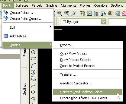
The convert Land Desktop points feature is not really new to Civil 3D. This utility could be downloaded from the Autodesk Support website under the Utilities & Driver section.

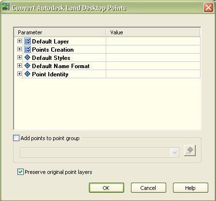
In the 2007 release this conversion utility was added to the Points menu, located under Utilities. After selecting the "Convert Land Desktop Points" option, a dialog box will appear prompting you to select parameters to apply to the new Civil 3D Point objects. You can set a variety of point settings such as, default layers, point creation settings, default styles, default name format, and point identity. Users can also select a default point group to which these points will be applied. There is also a check box to indicate if the original point layers are to be preserved enabling us to transfer directly from LDT to Civil 3D.


This command provides another layer of functionality for getting point data into Civil 3D from Land Desktop. Some other transfer methods would include XML import/export, importing Land Desktop Data, and exporting/importing of points. Some care should be taken to preserve data integrity. If you are planning on using your file in Land Desktop, there is no utility to convert back to Land Desktop Points.